Almost everything else about the location is a set of trade-offs, and this page sets them out without smoothing them over. The site is not on an arterial road. There is no operational metro anywhere near it. The nearest railway station of any kind is more than nine kilometres away by road. And the road network around the parcel is unusually indirect, so several places that look close on a map are not close to drive to. Inside the Bengaluru search area, Nambiar Bannerghatta helps buyers keep the map conversation grounded in actual routines instead of only distance claims.
This page uses only two sources: the environmental filing lodged for the project, and our own routed distance table computed from the corrected site coordinate. Every distance we publish below is road distance. Straight-line figures appear only where they are explicitly labelled as map distances, and only to show how far the map departs from the road.
The address of record for Urban Oasis
The parcel is assembled from 25 survey numbers spread across two revenue villages.
| Revenue village | Village code | Survey numbers |
|---|---|---|
| Yamare (census spelling "YAMRI") | 613217 | 97/1, 97/2, 98/1, 98/2, 100/1, 100/2, 100/4, 101/1, 101/2, 102/1, 103/1, 103/2, 103/6, 103/18, 103/19, 103/20, 103/21, 103/22, 103/23, 103/24, 103/25, 103/26 — 22 numbers |
| Dommasandra | 613354 | the remaining 3 numbers |
Both villages sit in Sarjapura Hobli, Anekal Taluk, Bengaluru Urban District, and the postal address runs through Dommasandra Post, 562125.
The address line we publish, and the one a buyer should use when ordering an encumbrance certificate or a revenue record search, is:
Yamare and Dommasandra Villages, Sarjapura Hobli, Anekal Taluk, Dommasandra Post, Bengaluru 562125.
Each element of that line has a practical consequence, which is why it is worth getting exactly right rather than treating it as address decoration.
The taluk — Anekal — determines which revenue and registration machinery the title runs through. Land records in Karnataka are indexed by village, hobli and taluk, and a search run against the wrong taluk simply returns nothing, or worse, returns records for a similarly named village elsewhere in the district.
The village matters more here than usual, because there are two of them. A buyer checking title on a plot in this scheme needs to know which of the 25 survey numbers their plot sits on, and therefore which village's records to pull. Twenty-two of the numbers are Yamare's; three are Dommasandra's. A search that covers only one village covers only part of the parcel.
The pincode, 562125, is Dommasandra's. It is not a Sarjapur town pincode and it is not a Bengaluru city one. That has ordinary day-to-day consequences — delivery serviceability, which branch of a bank or utility handles the address, how a courier routes a package.
The client brief names BMRDA as the approving authority, and we have seen no document from that authority either way. If that is right, planning approvals for this scheme run through the metropolitan region authority rather than through the city corporation, which would be consistent with a site in a gram panchayat area of Anekal taluk rather than inside city limits. That is a reading of an unconfirmed field, not a fact from the filing.
One further point about the address, and it is a genuine credibility marker rather than a marketing one. Modern Spaaces' own registered office is at No. 73/2, Chambenahalli Village, Dommasandra Post, Sarjapura Main Road — the same post office as this project's site address. The developer is building in the area it is based in. That is checkable, and it is not a claim we have taken from marketing material.
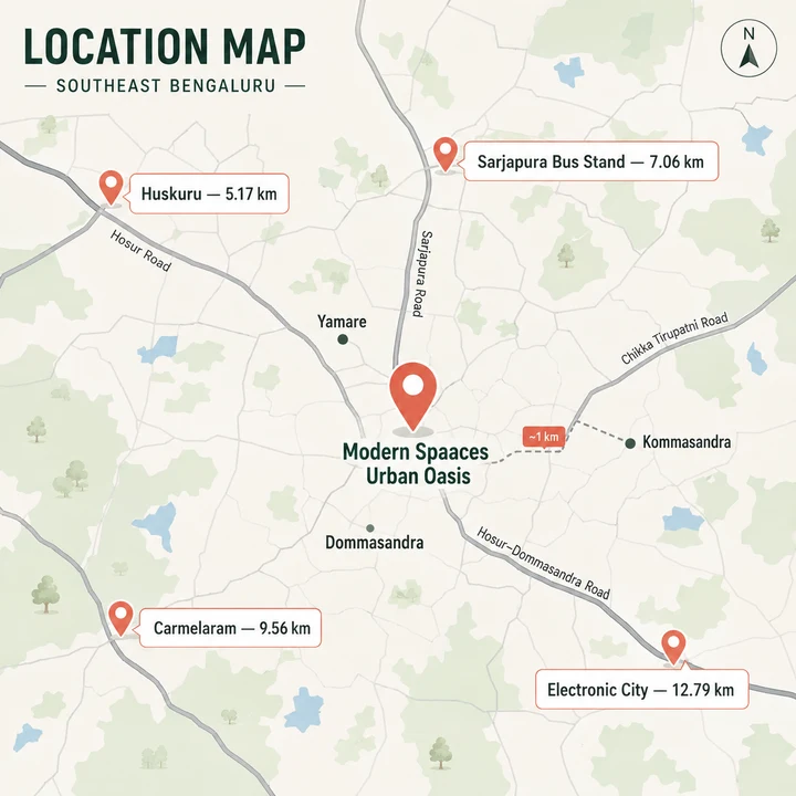
Kommasandra: the locality correction, and why it matters
The client brief's location field describes the site as "Kada Agrahara Road, Yamare, Kommasandra". Its address field, on the same document, says "Yamare Village & Dommasandra Village". Those two lines do not agree, and the disagreement needs resolving rather than papering over.
The filing settles it. The parcel's revenue villages are Yamare and Dommasandra. Kommasandra is not one of them, and it must not appear in the postal or legal address of this project.
What we will not do is overcorrect. Kommasandra is a real village — code 613207, in Muttanalluru Gram Panchayat, on the Chandapura–Dommasandra road — and its place node sits roughly 1.1 km in a straight line from the parcel. It is a neighbour, not a phantom, and not some distant part of the district that marketing material has grabbed at random. The honest description is that the parcel lies in Yamare and Dommasandra revenue villages, and that the neighbouring village of Kommasandra is about a kilometre away.
Why does a village name a kilometre out matter? Because the legal address of a property is not a description of its neighbourhood; it is the key to its records. A buyer who searches Kommasandra's revenue records for a plot that sits on Yamare Sy. No. 103/22 will find nothing, conclude the record does not exist, and either abandon a sound plot or accept an unverified one. The same applies to a bank's legal opinion and to any encumbrance search. Names near enough to sound right are the most expensive kind of error in a land transaction, because they do not look like errors.
The coordinate we publish for Urban Oasis, and what it actually is
We publish 12.86607, 77.74968 as the site coordinate.
That number is inferred, not surveyed, and we hold it at medium confidence. Here is exactly how we arrived at it, so the reader can judge it.
The boundary file lodged with the environmental application defines a bounding box with corners at 12.86419, 77.74645 and 12.86796, 77.75291. We publish the centre of that box. The corner coordinates are verified — they come from the filed boundary file. The centre point is our arithmetic.
The important caveat is the size of the box. It measures roughly 417 metres north to south and 701 metres east to west, enclosing about 29.2 hectares. The parcel itself is 14.6013 hectares. So the filed box is about twice the area of the land, and the parcel fills roughly half of it. The parcel is also genuinely elongated east to west, which the box's shape reflects.
What follows from that: the coordinate is a locator, not a gate position. It will put you on the land. It will not put you at an entrance, a marketing office or a corner. Treat it as accurate to a few hundred metres and no better. We publish it to five decimal places and no further, because further decimals would imply a precision the source does not carry.
The brief also supplied a second, different lat/long. We discard it and do not reproduce it. It sits about 663 metres from the centre of the filed box and falls outside the filed extent altogether — it is not a rounding difference, it points at land that is not part of this project. The Plus Code in the same brief, VQ82+27W, is the correct one of the two references it gives.
The road Urban Oasis fronts — and what the record does not tell us
This is one of the places where the honest answer is a gap.
Modern Spaaces' own website lists Urban Oasis as an upcoming villa project "Off Sarjapur Road". That is the developer's own description, and the word doing the work in it is off. It positions the project by corridor, not by frontage.
Nothing in the record we hold establishes which road the site actually fronts. The client brief names Kada Agrahara Road, and we record that as the brief's claim rather than as a fact — it is not corroborated by the filing. The accessible filing does not record an approach road width either, so we publish none.
What we will say plainly is what the routed table implies. Sarjapura Bus Stand is 7.06 km away by road. A site that fronted the main Sarjapur arterial in the town's immediate orbit would not be seven road-kilometres from its bus stand. This is an interior parcel reached from the corridor, not a plot on the corridor. Buyers evaluating villa schemes in this belt should assume an approach through village and connector roads, and should drive the actual route to the site rather than judging access from a corridor name.
That is not a criticism of the site. Interior parcels are how 36-acre villa schemes get assembled at all in this part of the district. But "Off Sarjapur Road" and "on Sarjapur Road" are different propositions, and only one of them is supported here.
What the filing proposes for this 36.08-acre parcel
The location makes more sense alongside what is proposed to be built on it. From the environmental filing:
| Field | Value |
|---|---|
| Land | 14.6013 ha = 36.08 acres |
| Units | 477 residential villas and a club house |
| Structure | GF + 2UF, maximum height 11.0 m |
| Built-up area | 182,631.25 sq m |
| Project cost | Rs 426.94 crore |
| Land status | Acquired — assembled by sale deed, joint development agreement from land owners, and exchange deeds, with conversions obtained |
| Proposal | SIA/KA/INFRA2/587993/2026, Fresh Terms of Reference, Category B1, Schedule 8(b) |
| Status | Under examination, last submitted 07/08/2026 |
Two things follow for a location assessment. First, an 11-metre height ceiling across 36 acres means this is a low-rise scheme — no towers, and a skyline that stays close to the ground. Second, the land status line matters: the parcel was assembled from multiple owners through a mix of instruments, which is consistent with 25 survey numbers across two villages, and the filing records that conversions have been obtained.
Nothing has been granted. The application is under examination. There is no signed certificate, no state file number, no Terms of Reference and no environmental clearance.
Schools within 4.8 km of Urban Oasis
This is the location's genuine strength, and it is unusual to find this density of established schooling this close to a 36-acre villa parcel. The first six entries below sit inside 4.3 km by road; the rest fall inside 4.8 km.
| School | Road distance from the site |
|---|---|
| Head Start Educational Academy | 2.18 km |
| Divine Providence School | 2.96 km |
| Oakridge International School | 3.21 km |
| Bethany High Sarjapur | 3.31 km |
| Kunskapsskolan Bengaluru | 4.25 km |
| The International School Bangalore | 4.29 km |
| United World Academy | 4.34 km |
| GIG International School | 4.44 km |
| Silver Oaks International School | 4.52 km |
| Inventure Academy | 4.77 km |
Widening the ring a little adds more established names: Global Indian International School at 5.24 km, Greenwood High at 5.35 km, Delhi Public School Bangalore East at 6.35 km, Harvest International School at 7.18 km, Ebenezer International School at 7.41 km and Deens Academy Gunjur Campus at 7.44 km — all by road.
Two caveats a careful parent should hold onto. Kunskapsskolan's 4.25 km is a road figure with a detour ratio of ×2.49 — it is 1.71 km away in a straight line. On a map it looks like a walk. It is not. Bethany High Sarjapur is similar, 1.74 km straight-line against 3.31 km by road. And school-run traffic in this belt at 7.30 in the morning is its own phenomenon, which no routing engine models. Drive the route at the actual hour before you rely on it.
Higher education around Yamare
| Institution | Road distance |
|---|---|
| International School Of Management Excellence | 3.85 km |
| ALLEN Career Institute | 5.73 km |
| National School of Business | 6.74 km |
| Krupanidhi Institutions | 9.04 km |
| Azim Premji University | 9.09 km |
| Xavier Institute of Management and Entrepreneurship | 10.37 km |
| PESU Electronic City Campus | 11.43 km |
| Symbiosis Institute of Business Management | 12.35 km |
ALLEN Career Institute is the sharpest example on this whole page of a map figure that misleads: 1.63 km straight-line against 5.73 km by road, a detour ratio of ×3.52. Azim Premji University is nearly as bad at ×2.36.
Employment: the Sarjapur and Electronic City belt
The site sits between two employment concentrations rather than inside either. Nothing is very close; a great deal is between seven and thirteen kilometres.
| Workplace | Road distance |
|---|---|
| Wipro SEZ | 7.66 km |
| Prestige Tech Habitat | 8.92 km |
| RGA Tech Park | 9.36 km |
| SABIC India Technology Center | 9.43 km |
| TCS Think Campus | 10.20 km |
| Sattva South Avenue | 10.24 km |
| Salarpuria Sattva Alexandria Tech Park | 10.26 km |
| Tech Mahindra | 10.33 km |
| Gold Hill Excelsior Park | 10.80 km |
| Maruthi Concorde Tech Park | 11.28 km |
| Infosys Foundation, Konappana Agrahara | 11.34 km |
| Wipro Corporate Office | 11.50 km |
| Sattva Spectrum | 11.86 km |
| HCL Technologies | 11.89 km |
| Tejas Networks | 12.06 km |
| Electronic City | 12.79 km |
| Delta Electronics, Bommasandra | 13.06 km |
| Biocon, Hebbagodi | 14.67 km |
Bellandur Road is 12.54 km by road and Huskur Road 12.64 km.
Two of these carry warnings. SABIC India Technology Center is 3.34 km straight-line and 9.43 km by road — a ×2.83 detour, the second-worst divergence in our whole table. And Biocon Hebbagodi at ×1.73 is materially further to drive than it looks. The Electronic City cluster generally reads better on a map than it drives, because the road network between this parcel and the Hosur Road belt is indirect.
The honest summary for a commuter: this is a ten-to-thirteen kilometre commute to most of the employment a buyer at this price point is likely to be working in, on roads that are congested at peak. It is not a walk-to-work location and it does not pretend to be one.
Rail from Yamare: Carmelaram, Heelalige, and no metro
| Station | Road distance |
|---|---|
| Carmelaram | 9.56 km |
| Heelalige | 9.74 km |
There is no operational metro station near this site. Carmelaram, at 9.56 km by road, is the nearest rail of any kind. We are not going to gesture at future metro alignments: no alignment or station location relevant to this parcel has been published, and a station that has not been sited is not a location benefit.
Both stations carry meaningful detour ratios — Carmelaram at ×1.45 and Heelalige at ×1.35 — so both are further to drive than the map suggests. Neither is realistically a walk-or-cycle proposition from the site. Rail access here means a drive or an auto to the station first.
Buses and the route into Sarjapura town
Sarjapura Bus Stand is 7.06 km by road from the site. Its straight-line distance is 3.93 km, giving a detour ratio of ×1.80 — one of the larger divergences in the transit table. The bus stand is, in map terms, about half as far away as the drive actually is.
That single figure is a fair proxy for how this location works. The town centre a buyer will treat as their base for everyday errands, transport and services is a genuine drive away, not a stroll.
Huskuru appears in our routed table at 5.17 km, with the lowest detour ratio of any transit-table entry at ×1.20 — meaning the road there runs unusually directly. We list it as a locality, not as a station.
Healthcare near Dommasandra and Sarjapura
| Facility | Road distance |
|---|---|
| Sri Lakshmi Multi Speciality Hospital | 2.70 km |
| Healing Hands Clinic, Sarjapura | 4.91 km |
| Spandana | 5.03 km |
| Sarjapura Urban Primary Health Centre | 6.97 km |
| Government Hospital, Gunjur | 7.64 km |
| Town Hospital | 7.76 km |
| Snehadaan Hospital | 7.82 km |
| Sahasra Hospital | 9.14 km |
| Sree Venkateshwara Hospital | 9.87 km |
| Athreya Hospital, Chandapura | 11.28 km |
| Apollo Clinic | 11.55 km |
| Sparsh Hospital, Bengaluru Urban | 11.56 km |
| Mazumdar Shaw Medical Center | 11.61 km |
| Narayana Hrudayalaya | 11.76 km |
The nearest hospital of any size is Sri Lakshmi Multi Speciality at 2.70 km — a genuinely useful figure, and the closest thing on this page to convenient emergency access. Beyond it, the picture thins out until the Bommasandra and Electronic City medical cluster at eleven to twelve kilometres, which is where the large tertiary institutions sit.
Two nearby facilities are worse than they look on a map. Healing Hands Clinic is 1.97 km straight-line but 4.91 km by road (×2.50), and Spandana is 1.89 km straight-line but 5.03 km by road (×2.65). A buyer estimating emergency access from a map here would be out by a factor of two and a half. Estimate it from the road figures.
Retail, markets and everyday needs
This is the location's weakest dimension today, and there is no honest way to dress it up.
| Destination | Road distance |
|---|---|
| Aruani Grid | 2.79 km |
| Confident Square Mall | 3.63 km |
| Pratham Motors | 4.01 km |
| CBR Convention Centre | 4.21 km |
| Discovate Studios | 4.95 km |
| SR Akshata Convention Hall | 6.88 km |
| Ravi Theater | 7.15 km |
| APMC Market | 7.82 km |
| CSK Mall | 8.40 km |
| Manthra Convention Centre | 8.77 km |
| Arcadia | 9.69 km |
| M5 ECity Mall | 10.91 km |
The nearest organised retail of any scale is Confident Square Mall at 3.63 km, and even that carries a ×2.29 detour ratio — 1.59 km on the map against 3.63 km on the road. The nearest market node in our table, APMC Market, is 7.82 km by road with a ×1.75 detour. The larger malls are ten kilometres out.
We list these destinations under the names our routed source carries and do not characterise what they sell. A buyer should assume that daily provisioning in the early years of occupation will be local-shop scale, with anything larger involving a drive. In a 477-villa community, in-project convenience retail often follows occupation — but nothing of that kind is recorded in the accessible filing, so we make no claim about it.
Water and open ground around Yamare
| Lake | Road distance |
|---|---|
| Dommasandra Lake | 1.30 km |
| Yamare Lake | 2.56 km |
| Thiagalara Chowdenahalli Lake | 3.63 km |
| Hosahalli Lake | 4.76 km |
| Hagondahalli Lake | 5.00 km |
| Huskur Lake | 5.02 km |
| Sulikunte Chikka Kere | 5.18 km |
| Sompura Lake | 5.27 km |
| Sarjapur Doddakere Lake | 5.58 km |
Dommasandra Lake at 1.30 km is the nearest, and at ×1.34 its detour ratio is among the milder ones in this group. Yamare Lake — the parcel's own namesake village tank — is 1.31 km away in a straight line but 2.56 km by road, a ×1.95 detour. It is nearly next door and nearly twice as far to drive to.
We make no claim about the condition, water level or public access of any of these bodies. They are recorded here as geography, not as amenities.
Why the map understates the drive to Urban Oasis
Across every category above, one pattern repeats: road distances here run well ahead of straight-line distances. These are the worst divergences in our table.
| Destination | Straight-line | By road | Ratio |
|---|---|---|---|
| ALLEN Career Institute | 1.63 km | 5.73 km | ×3.52 |
| SABIC India Technology Center | 3.34 km | 9.43 km | ×2.83 |
| Spandana | 1.89 km | 5.03 km | ×2.65 |
| Nambiar District 25 | 1.78 km | 4.45 km | ×2.50 |
| Healing Hands Clinic, Sarjapura | 1.97 km | 4.91 km | ×2.50 |
| Kunskapsskolan Bengaluru | 1.71 km | 4.25 km | ×2.49 |
| Azim Premji University | 3.85 km | 9.09 km | ×2.36 |
| Confident Square Mall | 1.59 km | 3.63 km | ×2.29 |
| Aruani Grid | 1.41 km | 2.79 km | ×1.98 |
| Yamare Lake | 1.31 km | 2.56 km | ×1.95 |
A detour ratio above about 1.6 means the road ranking has diverged from the map ranking — the order in which places appear closest changes once you drive rather than measure. Around this parcel that happens constantly. The straight line from the site to most of its near neighbours crosses land with no through road, so traffic funnels onto a small number of connecting roads and the actual route doubles back.
The practical consequence for a buyer is simple and worth stating in one sentence: do not evaluate this location by opening a map and eyeballing distances. The eyeball estimate will be wrong by a factor approaching two for many of the destinations that matter most — the nearest mall, two of the nearest clinics, one of the nearest international schools, and a nearby villa-format development.
How to read the distance figures on this page
Every figure above is road distance on the OpenStreetMap driving profile, computed from the coordinate 12.86607, 77.74968. Where a straight-line figure appears, it is labelled as one and used only for comparison — never as a distance in its own right.
We do not publish single drive-time numbers. Free-flow routing minutes are close to meaningless in this corridor — they describe a road that does not exist at any hour a commuter would use it. Where a sense of time is genuinely useful, we give a band between an uncongested floor and a congested ceiling, and the ceiling applies a published 2025 Bengaluru city-street congestion figure. On that basis, Carmelaram station at 9.56 km sits in a band of roughly 16 to 35 minutes, Wipro SEZ at 7.66 km in a band of roughly 14 to 28 minutes, and Electronic City at 12.79 km in a band of roughly 20 to 46 minutes. Those are modelled bands, not measured journeys. Nothing replaces driving the route yourself at the hour you would actually be driving it.
Destination coordinates come from live OpenStreetMap records. Where a point of interest is not carried in OpenStreetMap, it was dropped rather than guessed — which is why some places a buyer might expect to see are absent from these tables. Their absence means we had no verifiable coordinate, not that they do not exist.
The trade-offs of the Yamare and Dommasandra location, stated plainly
What is genuinely good here. The school density is the real story — ten schools inside 4.8 km by road, six of them inside 4.3 km, several of them long-established international names. That is not a promise about the future; those schools are operating now. Sri Lakshmi Multi Speciality at 2.70 km gives the location a nearby hospital, which many parcels this far out do not have. Dommasandra Lake is 1.30 km away. And the developer's own registered office shares this project's post office, which means the builder knows this ground. A same-developer shortlist can feel simpler than it really is; Modern Spaaces Sarjapur Road keeps attention on how each Bengaluru address solves a different routine, budget, and documentation question.
What is not good, and will not become good quickly. There is no metro and no rail within nine kilometres. There is no organised retail of scale within three and a half kilometres, and the nearest mall is a ×2.29 detour away. Employment is a ten-to-thirteen kilometre drive on congested roads. Sarjapura town's bus stand — the obvious transport anchor — is seven road-kilometres out, nearly double its map distance.
What is uncertain. The road the site fronts is not established by any document we hold. The approach is not described in the accessible filing. The coordinate is good to a few hundred metres, not to a gate. And every piece of infrastructure named on this page is what exists today; nothing here is counted as proposed, because we have chosen not to publish infrastructure that has not been sited.
What a buyer should actually do. Drive to the coordinate. Drive from it to the school you would use, at 7.30 on a weekday. Drive from it to your office at 9.00. Then check the survey number of the specific plot you are being offered against the correct village — Yamare or Dommasandra — and pull the encumbrance certificate for that village, not for Kommasandra.
The regulatory position, without which none of the above means anything
Urban Oasis is not registered with the Karnataka Real Estate Regulatory Authority. It holds no registration number, and we publish none.
Section 3 of the Real Estate (Regulation and Development) Act 2016 is unambiguous on what that means. A project in a registrable class cannot lawfully be advertised, marketed, booked or sold until registration has been granted. Not "should not" — cannot. Anyone inviting a booking, a deposit or an expression of interest backed by money on this project today is inviting it on a scheme that has no registration.
The environmental position is at an equally early stage. The application for Urban Oasis, proposal number SIA/KA/INFRA2/587993/2026, was filed on 7 August 2026 and is under examination. No Terms of Reference has been granted and no environmental clearance has been granted. There is no signed certificate and no state file number on the record.
PropNewz is not the developer and not a broker. This page is an information and enquiry resource for a scheme at the approvals stage. It is not a booking channel, and nothing on it should be read as an invitation to pay money for a unit that does not yet legally exist to be sold.
Urban Oasis by Modern Spaaces Location — frequently asked questions
How long is the commute from Urban Oasis to Electronic City and the Sarjapur tech offices?
We publish kilometres by road, because a single drive-time number for this corridor is meaningless. Wipro SEZ is 7.66 km by road; Prestige Tech Habitat is 8.92 km; RGA Tech Park is 9.36 km; Infosys Foundation Konappana Agrahara is 11.34 km; Electronic City is 12.79 km; Bellandur Road is 12.54 km. On a modelled basis the Electronic City run falls somewhere between roughly 20 minutes in clear conditions and about 46 minutes at a congested city-street rate — a floor and a ceiling, not a measurement, and the honest answer is that your commute will move around inside that band by hour and by day.
Which schools are near Urban Oasis?
The school cluster is this location's genuine strength, and for a family buying a four or five-bedroom villa it is probably the most relevant fact on the page. All distances below are road distances from the site.
| School | By road |
|---|---|
| Head Start Educational Academy | 2.18 km |
| Divine Providence School | 2.96 km |
| Oakridge International School | 3.21 km |
| Bethany High Sarjapur | 3.31 km |
| Kunskapsskolan Bengaluru | 4.25 km |
| The International School Bangalore | 4.29 km |
The International School of Management Excellence is 3.85 km by road. Note that several of these sit much closer on a map than on the road — Kunskapsskolan is 1.71 km in a straight line but 4.25 km by road, so plan school runs on road distance.
Is there a metro or railway station near Urban Oasis?
There is no operational metro station near this site, and this page will not imply one. Proposed alignments are sometimes cited for this corridor; no alignment or station location has been published that would let anyone state a distance, so we state none. The nearest rail of any kind is Carmelaram railway station at 9.56 km by road, with Heelalige at 9.74 km by road. Both are suburban rail, not metro. The nearest bus interchange of any size is Sarjapura Bus Stand at 7.06 km by road. Realistically, Urban Oasis is a car-dependent location today, and any buyer should price that into the decision rather than into a future line.
Is Urban Oasis in Kommasandra?
Not in the postal or legal sense, and this is worth getting right because material in circulation places it there. The parcel's revenue villages are Yamare and Dommasandra. Kommasandra should not appear in the project's postal or legal address. That said, Kommasandra is not a phantom and not some distant part of the district: it is a real neighbouring village, code 613207, in Muttanalluru Gram Panchayat on the Chandapura–Dommasandra road, and its place node sits about a kilometre from this parcel in a straight line — that is a map measurement, not a road distance. So the name attaches loosely to the general area while belonging to a different village. The honest form is that the parcel lies in Yamare and Dommasandra, with Kommasandra as a neighbour.
How many towers or blocks will Urban Oasis have, and why can you not tell me?
There are no towers — the filed envelope is ground plus two upper floors at a maximum of 11.0 m, which is a low-rise villa format throughout. As for how the 477 villas are grouped into clusters, phases or blocks, we cannot tell you, and we would rather say so than guess. The reason is simple: no layout plan for Urban Oasis has been published, and no plan has been passed by a planning authority, so there is no document that divides the site. The filing records the aggregate — 477 villas and a club house — and stops there. Any cluster count, phase plan or villa-numbering scheme you encounter at this stage is marketing, not record.
Enquire about Urban Oasis by Modern Spaaces
Urban Oasis by Modern Spaaces is at the stage where the useful thing is information rather than a booking, because there is no lawful booking to make. Leave your details and we will tell you when the position changes — when a Karnataka RERA number is issued, when the environmental file moves, and when the developer publishes a price, a floor plate and an amenity schedule. The enquiry form asks for a name, phone number, email address and message; name and phone are required.